The Anime Trip
🌐 EN ▾
ItalianoEnglish繁體中文(台灣)繁體中文(香港)日本語
PLAN YOUR TRIPMy tripSign in / Sign upSign in / Sign up

Tokyo

Mount Tenjō (Kōzu-shima Island)

天上山

Open on the mapwith over 1,800 wonders of Japan

Mount Tenjō (Kōzu-shima Island)
photo by Saigen Jiro · CC0
Mount Tenjō (Kōzu-shima Island)
photo by Y.Kowashi · CC BY 3.0

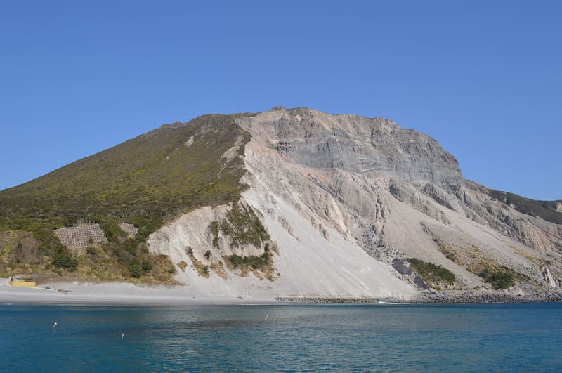
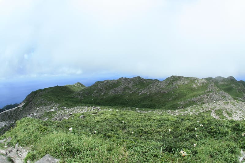
The 572-metre lava cone formed in the eruption of 29 July 838, and today its flat summit ridge holds three lakes, including a heart-shaped one sacred to local fishermen.

The mountain is on four official lists cited by the municipal website: the ‘Hundred Flower Mountains’ (花の百名山), the ‘New Hundred Mountains of Japan’ (新日本百名山), the ‘Hundred Mountains of Kantō’ (関東百名山) and the ‘New Hundred Views of Tokyo’ (新東京百景), where it is described as ‘黒潮の大展望台’ (a great viewpoint over the Kuroshio current). From the summit you can see Izu Ōshima, Niijima, Miyake-jima and the Izu peninsula. Wikipedia notes that the summit flora includes species endemic to the Izu islands, among them rare orchids, with flowers all year round.

Mount Tenjō (天上山, 571.8/572 m) is the volcano and the highest point of Kōzu-shima Island, in the municipality of the same name in Tokyo prefecture; it is not to be confused with the Mount Tenjō of the same name near Lake Kawaguchi, in Yamanashi. According to the Wikipedia infobox it formed in an eruption that began on 29 July 838 (year 5 of the Jōwa era), which produced pyroclastic flows and surges and finally a lava dome. The official municipal website describes it as ‘台形状’ (trapezoidal in shape), recognisable from the sea although, as an island mountain, it has ‘深山幽谷の趣’ (the atmosphere of a deep valley). The summit is a relatively flat surface with three lakes (Baba, Fudō, Sendai) and two sandy stretches called the ‘front desert’ and the ‘rear desert’.

ℹ️ From Kōzu-shima port it is a 40-minute walk to the two trailheads, Kuroshima and Shirashima. The official site kozushima.com warns: ‘通年登山可能ですが、安全のため日没前に下山をしてください’ (you can climb all year round, but for safety you must come down before sunset). Lake Fudō-ike, heart-shaped, is traditionally sacred to local fishermen, with a shrine to the dragon god in the middle and small buildings dedicated to Fudō and Dainichi Nyorai.

🚉 白島登山口入口 · 25 min walk

Holidays in Japan? Plan them with us.Over 2,000 real places, a day-by-day itinerary.FreeOpen the map →

Sources: ja.wikipedia.org · kozushima.com

Nearby
All series · Open the map

Mount Tenjō (Kōzu-shima Island)
Open on the mapwith over 1,800 wonders of Japan
Mount Tenjō (Kōzu-shima Island)
photo by Saigen Jiro · CC0
Mount Tenjō (Kōzu-shima Island)
photo by Y.Kowashi · CC BY 3.0

The 572-metre lava cone formed in the eruption of 29 July 838, and today its flat summit ridge holds three lakes, including a heart-shaped one sacred to local fishermen.

The mountain is on four official lists cited by the municipal website: the ‘Hundred Flower Mountains’ (花の百名山), the ‘New Hundred Mountains of Japan’ (新日本百名山), the ‘Hundred Mountains of Kantō’ (関東百名山) and the ‘New Hundred Views of Tokyo’ (新東京百景), where it is described as ‘黒潮の大展望台’ (a great viewpoint over the Kuroshio current). From the summit you can see Izu Ōshima, Niijima, Miyake-jima and the Izu peninsula. Wikipedia notes that the summit flora includes species endemic to the Izu islands, among them rare orchids, with flowers all year round.

Mount Tenjō (天上山, 571.8/572 m) is the volcano and the highest point of Kōzu-shima Island, in the municipality of the same name in Tokyo prefecture; it is not to be confused with the Mount Tenjō of the same name near Lake Kawaguchi, in Yamanashi. According to the Wikipedia infobox it formed in an eruption that began on 29 July 838 (year 5 of the Jōwa era), which produced pyroclastic flows and surges and finally a lava dome. The official municipal website describes it as ‘台形状’ (trapezoidal in shape), recognisable from the sea although, as an island mountain, it has ‘深山幽谷の趣’ (the atmosphere of a deep valley). The summit is a relatively flat surface with three lakes (Baba, Fudō, Sendai) and two sandy stretches called the ‘front desert’ and the ‘rear desert’.

ℹ️ From Kōzu-shima port it is a 40-minute walk to the two trailheads, Kuroshima and Shirashima. The official site kozushima.com warns: ‘通年登山可能ですが、安全のため日没前に下山をしてください’ (you can climb all year round, but for safety you must come down before sunset). Lake Fudō-ike, heart-shaped, is traditionally sacred to local fishermen, with a shrine to the dragon god in the middle and small buildings dedicated to Fudō and Dainichi Nyorai.

🚉 白島登山口入口 · 25 min walk

Holidays in Japan? Plan them with us.Over 2,000 real places, a day-by-day itinerary.FreeOpen the map →

Sources: ja.wikipedia.org · kozushima.com

Nearby