The Anime Trip
🌐 EN ▾
ItalianoEnglish繁體中文(台灣)繁體中文(香港)日本語
PLAN YOUR TRIPMy tripSign in / Sign upSign in / Sign up

Miyazaki

Umagase — Hyūga-misaki

日向岬・馬ヶ背

Open on the mapwith over 1,800 wonders of Japan

Umagase — Hyūga-misaki (日向岬・馬ヶ背)
photo by ja:User:Sanjo · CC BY-SA 3.0
Umagase — Hyūga-misaki (日向岬・馬ヶ背)
photo by 長曽我部政幸 · CC BY-SA 3.0

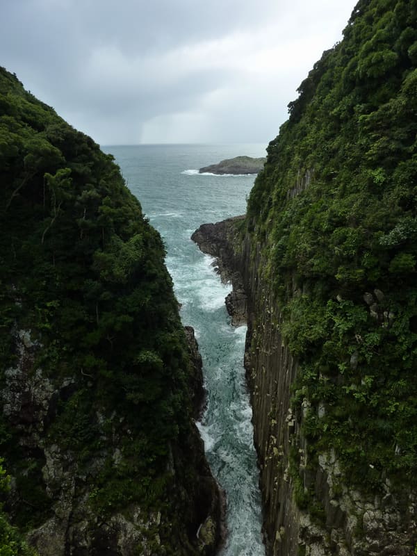
Columnar cliffs 70 m high: since 2022 a glass platform has looked down on them from above.

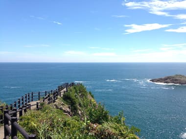
The walls of rock columns, up to 70 metres high, were formed by an undersea eruption about 15 million years ago: the lava cooled into columns of welded tuff, then the sea exposed the formation, the most extensive of its kind in Japan, by eroding the coast. From the car park, a path of about 540 metres (ten minutes, with steep sections and changes in level) leads to the viewpoint; in 2022 ‘Skerutcha!’ was added, a glass terrace suspended over the drop of the cliff. The name, which means ‘horse's back’, comes from the narrow, elongated shape of the headland.

The Hyūga-misaki headland, with its jagged coastline, is part of Nippō Coast Quasi-National Park. The Umagase rock columns were designated a national Natural Monument on 13 February 2018.

ℹ️ Free car park, 70 spaces. The Umagase-jaya kiosk is open 9:10–17:50 from April to September and 8:40–17:20 from October to March. A few steps away, the Kurusu-no-umi headland (rocks in the shape of a cross) is another stop on the same walk, not covered by this entry.

🚉 御鉾ヶ浦公園 (Mihokogaura Kōen) · 16 min walk

Holidays in Japan? Plan them with us.Over 2,000 real places, a day-by-day itinerary.FreeOpen the map →

Sources: kanko-miyazaki.jp · ja.wikipedia.org

Nearby

All series · Open the map

Umagase — Hyūga-misaki (日向岬・馬ヶ背)
Open on the mapwith over 1,800 wonders of Japan
Umagase — Hyūga-misaki (日向岬・馬ヶ背)
photo by ja:User:Sanjo · CC BY-SA 3.0
Umagase — Hyūga-misaki (日向岬・馬ヶ背)
photo by 長曽我部政幸 · CC BY-SA 3.0

Columnar cliffs 70 m high: since 2022 a glass platform has looked down on them from above.

The walls of rock columns, up to 70 metres high, were formed by an undersea eruption about 15 million years ago: the lava cooled into columns of welded tuff, then the sea exposed the formation, the most extensive of its kind in Japan, by eroding the coast. From the car park, a path of about 540 metres (ten minutes, with steep sections and changes in level) leads to the viewpoint; in 2022 ‘Skerutcha!’ was added, a glass terrace suspended over the drop of the cliff. The name, which means ‘horse's back’, comes from the narrow, elongated shape of the headland.

The Hyūga-misaki headland, with its jagged coastline, is part of Nippō Coast Quasi-National Park. The Umagase rock columns were designated a national Natural Monument on 13 February 2018.

ℹ️ Free car park, 70 spaces. The Umagase-jaya kiosk is open 9:10–17:50 from April to September and 8:40–17:20 from October to March. A few steps away, the Kurusu-no-umi headland (rocks in the shape of a cross) is another stop on the same walk, not covered by this entry.

🚉 御鉾ヶ浦公園 (Mihokogaura Kōen) · 16 min walk

Holidays in Japan? Plan them with us.Over 2,000 real places, a day-by-day itinerary.FreeOpen the map →

Sources: kanko-miyazaki.jp · ja.wikipedia.org

Nearby