The Anime Trip
🌐 EN ▾
ItalianoEnglish繁體中文(台灣)繁體中文(香港)日本語
PLAN YOUR TRIPMy tripSign in / Sign upSign in / Sign up
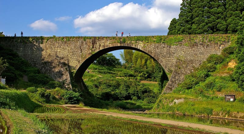
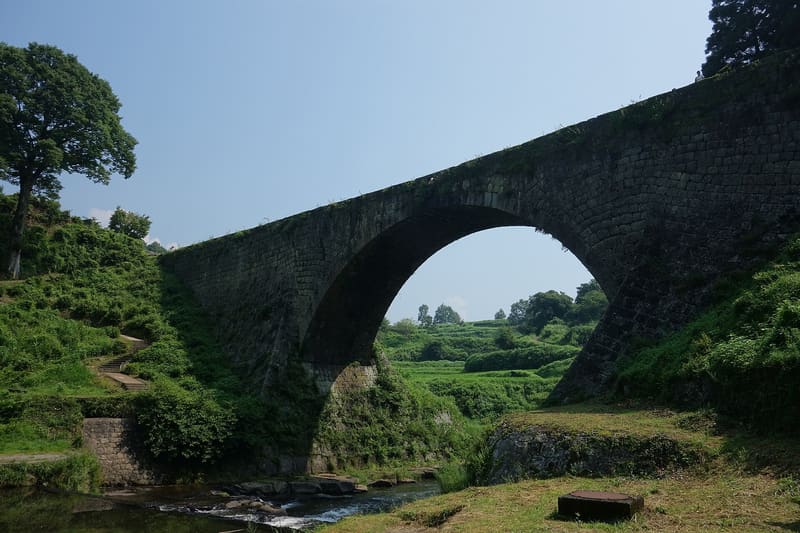
Tsūjunkyō Bridge (通潤橋)
photo by masamic, edited by Laitche · CC BY-SA 3.0
Tsūjunkyō Bridge (通潤橋)
photo by 690 Noda · CC BY 3.0

National Treasure since 2023, the first among engineering works: it has irrigated 100 hectares since 1854.

The bridge carries water from one side of the valley to the other, and every so often it releases it: the outlets are opened and two jets shoot out from the centre of the arch, twenty-one metres above the valley floor. Since August 2026 you can only watch it from the ground; walking on the bridge is suspended for the whole year, while engineers survey it in three dimensions to find out whether the earthquake has moved it.

Futa Yasunosuke, intendant of the village of Yabe (now Yamato), had it built in 1854 to bring water to a plateau that had none. It is about 78 metres long, 6.6 wide and about 21.3 high, with an arch radius of 28.1 metres; inside it run 119 metres of stone pipe that are part of a network of about 42 kilometres, fed by the Sasahara River six kilometres away, which still irrigates about a hundred hectares of the Shiraito plateau. The water discharge that made it famous serves to flush sand out of the pipe, and it is the only stone arch bridge in Japan able to do so. In 1960 it was designated 重要文化財, an Important Cultural Property, and in 2023 国宝, a National Treasure, the highest grade in the Japanese register: it is the first civil engineering work in the country to receive it.

ℹ️ From outside you can look freely and there is nothing to pay; the car park has 136 spaces and is free. The jet is at around 13:00 and lasts about a quarter of an hour; on four dates in 2026 it happens twice, at 11:00 and 13:00, and it can be called off suddenly because of rain. Known suspensions in 2026: 30 August for cleaning the stone walls, 5 and 7 September for the Hassaku festival. Walking on the bridge (橋上観覧) cost 500 yen for high school age and above and 200 yen for elementary and junior high school pupils, on discharge days from 10:00 to 15:00, with tickets from the Tsujun Mierre Terrace shop. ⚠️ The notice of 12 August 2026 suspends it for the whole year. The water discharges resumed on 13 August 2026 and can be watched from the areas declared safe. The Yamato municipality's page, updated on 31 August 2026, says that the 28 July earthquake did not dislodge any stones or deform the arch, that the leak test of the three pipes carried out on 3 August was successful, and that cracks remain in the covering soil near the wall on the right bank, the same ones as in 2016. If the three-dimensional survey planned for the second half of 2026 found any deterioration, the discharges could stop again: before setting off to see them, check again.

🚉 通潤山荘 · 5 min walk

Holidays in Japan? Plan them with us.Over 2,000 real places, a day-by-day itinerary.FreeOpen the map →

Sources: tsujunbridge.jp · tsujunbridge.jp · town.kumamoto-yamato.lg.jp · newt.net
Nearby

All series · Open the map

Tsūjunkyō Bridge (通潤橋)
Open on the mapwith over 1,800 wonders of Japan
Tsūjunkyō Bridge (通潤橋)
photo by masamic, edited by Laitche · CC BY-SA 3.0
Tsūjunkyō Bridge (通潤橋)
photo by 690 Noda · CC BY 3.0

National Treasure since 2023, the first among engineering works: it has irrigated 100 hectares since 1854.

The bridge carries water from one side of the valley to the other, and every so often it releases it: the outlets are opened and two jets shoot out from the centre of the arch, twenty-one metres above the valley floor. Since August 2026 you can only watch it from the ground; walking on the bridge is suspended for the whole year, while engineers survey it in three dimensions to find out whether the earthquake has moved it.

Futa Yasunosuke, intendant of the village of Yabe (now Yamato), had it built in 1854 to bring water to a plateau that had none. It is about 78 metres long, 6.6 wide and about 21.3 high, with an arch radius of 28.1 metres; inside it run 119 metres of stone pipe that are part of a network of about 42 kilometres, fed by the Sasahara River six kilometres away, which still irrigates about a hundred hectares of the Shiraito plateau. The water discharge that made it famous serves to flush sand out of the pipe, and it is the only stone arch bridge in Japan able to do so. In 1960 it was designated 重要文化財, an Important Cultural Property, and in 2023 国宝, a National Treasure, the highest grade in the Japanese register: it is the first civil engineering work in the country to receive it.

ℹ️ From outside you can look freely and there is nothing to pay; the car park has 136 spaces and is free. The jet is at around 13:00 and lasts about a quarter of an hour; on four dates in 2026 it happens twice, at 11:00 and 13:00, and it can be called off suddenly because of rain. Known suspensions in 2026: 30 August for cleaning the stone walls, 5 and 7 September for the Hassaku festival. Walking on the bridge (橋上観覧) cost 500 yen for high school age and above and 200 yen for elementary and junior high school pupils, on discharge days from 10:00 to 15:00, with tickets from the Tsujun Mierre Terrace shop. ⚠️ The notice of 12 August 2026 suspends it for the whole year. The water discharges resumed on 13 August 2026 and can be watched from the areas declared safe. The Yamato municipality's page, updated on 31 August 2026, says that the 28 July earthquake did not dislodge any stones or deform the arch, that the leak test of the three pipes carried out on 3 August was successful, and that cracks remain in the covering soil near the wall on the right bank, the same ones as in 2016. If the three-dimensional survey planned for the second half of 2026 found any deterioration, the discharges could stop again: before setting off to see them, check again.

🚉 通潤山荘 · 5 min walk

Holidays in Japan? Plan them with us.Over 2,000 real places, a day-by-day itinerary.FreeOpen the map →

Sources: tsujunbridge.jp · tsujunbridge.jp · town.kumamoto-yamato.lg.jp · newt.net

Nearby