The Anime Trip
🌐 EN ▾
ItalianoEnglish繁體中文(台灣)繁體中文(香港)日本語
PLAN YOUR TRIPMy tripSign in / Sign upSign in / Sign up
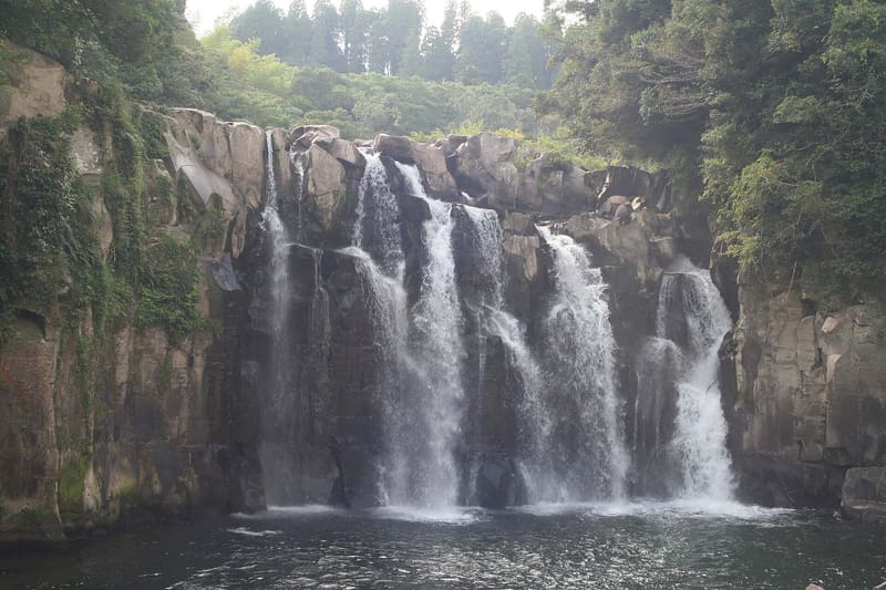
Sekinoo Falls (関之尾滝)
photo by Mitsuki-2368 · CC BY-SA 3.0
Sekinoo Falls (関之尾滝)
photo by ja:User:Sanjo · Public domain

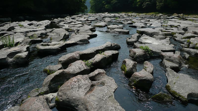
Upstream, 600 m of potholes: a Natural Monument since 1928, among the most extensive in the world.

The main waterfall is about 40 metres wide and 18 high, one of the ‘hundred waterfalls of Japan’ (日本の滝百選); beside it, two smaller Meiji-period waterfalls regulate the Kitamae irrigation canal. Upstream, the river has carved into the volcanic rock a field of potholes (甌穴, ōketsu) – cylindrical holes bored by stones that the current keeps spinning inside them – stretching about 600 metres with a maximum width of 80: the group was designated a national Natural Monument on 18 February 1928 and is described as among the most extensive in the world for this type of formation.

The site is in the municipality of Miyakonojo, in the southern interior of the prefecture, along a tributary that flows over a layer of welded tuff (溶結凝灰岩) laid down by the great Kakuto pyroclastic flow about 330–340 thousand years ago: it is this rock, softer in some places, that the water has cut into the potholes and the drop of the waterfall. A suspension bridge lets you get close to the main fall, and a level path follows the river up to the pothole field further upstream.

ℹ️ Riverside park with free entry, open all year, with no opening hours or closing day stated on the official source. Free car park, about 250 spaces. About 20 minutes by car from the Miyakonojo IC toll gate.

🚉 関之尾滝 (o 関之滝) · 2 min walk

Holidays in Japan? Plan them with us.Over 2,000 real places, a day-by-day itinerary.FreeOpen the map →

Sources: city.miyakonojo.miyazaki.jp · city.miyakonojo.miyazaki.jp · ja.wikipedia.org

Nearby

All series · Open the map

Sekinoo Falls (関之尾滝)
Open on the mapwith over 1,800 wonders of Japan
Sekinoo Falls (関之尾滝)
photo by Mitsuki-2368 · CC BY-SA 3.0
Sekinoo Falls (関之尾滝)
photo by ja:User:Sanjo · Public domain

Upstream, 600 m of potholes: a Natural Monument since 1928, among the most extensive in the world.

The main waterfall is about 40 metres wide and 18 high, one of the ‘hundred waterfalls of Japan’ (日本の滝百選); beside it, two smaller Meiji-period waterfalls regulate the Kitamae irrigation canal. Upstream, the river has carved into the volcanic rock a field of potholes (甌穴, ōketsu) – cylindrical holes bored by stones that the current keeps spinning inside them – stretching about 600 metres with a maximum width of 80: the group was designated a national Natural Monument on 18 February 1928 and is described as among the most extensive in the world for this type of formation.

The site is in the municipality of Miyakonojo, in the southern interior of the prefecture, along a tributary that flows over a layer of welded tuff (溶結凝灰岩) laid down by the great Kakuto pyroclastic flow about 330–340 thousand years ago: it is this rock, softer in some places, that the water has cut into the potholes and the drop of the waterfall. A suspension bridge lets you get close to the main fall, and a level path follows the river up to the pothole field further upstream.

ℹ️ Riverside park with free entry, open all year, with no opening hours or closing day stated on the official source. Free car park, about 250 spaces. About 20 minutes by car from the Miyakonojo IC toll gate.

🚉 関之尾滝 (o 関之滝) · 2 min walk

Holidays in Japan? Plan them with us.Over 2,000 real places, a day-by-day itinerary.FreeOpen the map →

Sources: city.miyakonojo.miyazaki.jp · city.miyakonojo.miyazaki.jp · ja.wikipedia.org

Nearby