The Anime Trip
🌐 EN ▾
ItalianoEnglish繁體中文(台灣)繁體中文(香港)日本語
PLAN YOUR TRIPMy tripSign in / Sign upSign in / Sign up

Wakayama

Kōyasan — Okunoin, the mausoleum of Kōbō Daishi

奥之院

Open on the mapwith over 1,800 wonders of Japan

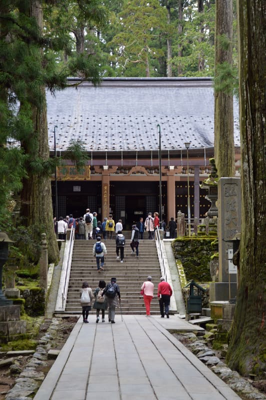
Kōyasan — Okunoin, the mausoleum of Kōbō Daishi (高野山・奥之院)
photo by Adam Jones from Kelowna, BC, Canada · CC BY-SA 2.0
Kōyasan — Okunoin, the mausoleum of Kōbō Daishi (高野山・奥之院)
photo by DimiTalen · CC0

200,000 gravestones among the cedars: food is brought to Kōbō Daishi twice a day.

From the first bridge (Ichinohashi) a path of about 2 kilometres, lined with centuries-old cedars, crosses the largest cemetery in Japan: more than 200,000 tombs, gravestones and memorials, including those of more than 60% of the feudal lords of the Sengoku period. Beyond the last bridge (Gobyōbashi) photography is forbidden: you enter the sacred area of the mausoleum of Kōbō Daishi (Kūkai), who died – according to the Shingon tradition he did not die but entered eternal meditation (入定) – in 835. Since then, every day at 6:00 and at 10:30, the monks still bring him food: the rite is called shōjingu and has continued without interruption for more than 1,200 years.

Together with the Danjō Garan, Okunoin is one of the two sacred centres of Kōyasan, founded by Kūkai in 816. The Tōrōdō (the Hall of Ten Thousand Lanterns) stands in front of the mausoleum. The path and the twelve temple districts of Kōyasan have been a UNESCO World Heritage Site since 7 July 2004, as part of the ‘Sacred Sites and Pilgrimage Routes in the Kii Mountain Range’.

ℹ️ The Tōrōdō is open 6:00–17:00; access to the crypt beneath the Tōrōdō closes at 16:45. Prayer ceremonies at 9:00, 10:20, 11:30, 12:40, 13:40, 14:40. The path itself, from the Ichinohashi to the Gobyōbashi, has no gate and takes about 30 minutes on foot; many visitors enter from the middle bridge (Nakanohashi), halving the walk. ‘Okunoin-mae’ bus stop, then 11 minutes on foot.

🚉 14 Okunoin-mae · 11 min walk

Holidays in Japan? Plan them with us.Over 2,000 real places, a day-by-day itinerary.FreeOpen the map →

Sources: ja.wikipedia.org · wakayama-kanko.or.jp

Nearby
All series · Open the map

Kōyasan — Okunoin, the mausoleum of Kōbō Daishi (高野山・奥之院)
Open on the mapwith over 1,800 wonders of Japan
Kōyasan — Okunoin, the mausoleum of Kōbō Daishi (高野山・奥之院)
photo by Adam Jones from Kelowna, BC, Canada · CC BY-SA 2.0
Kōyasan — Okunoin, the mausoleum of Kōbō Daishi (高野山・奥之院)
photo by DimiTalen · CC0

200,000 gravestones among the cedars: food is brought to Kōbō Daishi twice a day.

From the first bridge (Ichinohashi) a path of about 2 kilometres, lined with centuries-old cedars, crosses the largest cemetery in Japan: more than 200,000 tombs, gravestones and memorials, including those of more than 60% of the feudal lords of the Sengoku period. Beyond the last bridge (Gobyōbashi) photography is forbidden: you enter the sacred area of the mausoleum of Kōbō Daishi (Kūkai), who died – according to the Shingon tradition he did not die but entered eternal meditation (入定) – in 835. Since then, every day at 6:00 and at 10:30, the monks still bring him food: the rite is called shōjingu and has continued without interruption for more than 1,200 years.

Together with the Danjō Garan, Okunoin is one of the two sacred centres of Kōyasan, founded by Kūkai in 816. The Tōrōdō (the Hall of Ten Thousand Lanterns) stands in front of the mausoleum. The path and the twelve temple districts of Kōyasan have been a UNESCO World Heritage Site since 7 July 2004, as part of the ‘Sacred Sites and Pilgrimage Routes in the Kii Mountain Range’.

ℹ️ The Tōrōdō is open 6:00–17:00; access to the crypt beneath the Tōrōdō closes at 16:45. Prayer ceremonies at 9:00, 10:20, 11:30, 12:40, 13:40, 14:40. The path itself, from the Ichinohashi to the Gobyōbashi, has no gate and takes about 30 minutes on foot; many visitors enter from the middle bridge (Nakanohashi), halving the walk. ‘Okunoin-mae’ bus stop, then 11 minutes on foot.

🚉 14 Okunoin-mae · 11 min walk

Holidays in Japan? Plan them with us.Over 2,000 real places, a day-by-day itinerary.FreeOpen the map →

Sources: ja.wikipedia.org · wakayama-kanko.or.jp

Nearby