The Anime Trip
🌐 EN ▾
ItalianoEnglish繁體中文(台灣)繁體中文(香港)日本語
PLAN YOUR TRIPMy tripSign in / Sign upSign in / Sign up
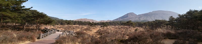
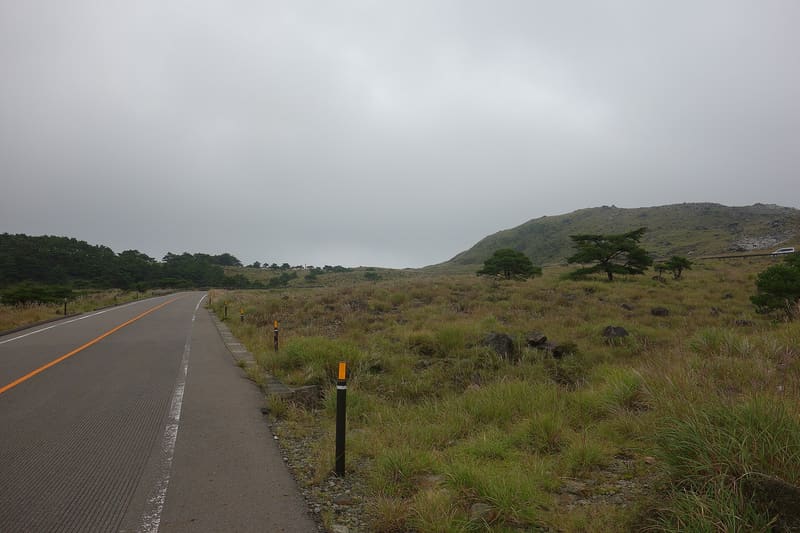
Ebino Plateau (えびの高原)
photo by clear_and_sunny · CC BY 3.0
Ebino Plateau (えびの高原)
photo by 690 Noda · CC BY 3.0

The name comes from the shrimp colour of the autumn susuki grass on Karakunidake.

The plateau lies at 1200 metres, in the northern section of Kirishima-Kinkōwan National Park, at the foot of Mount Karakunidake (1700 m, the highest in the range). The ‘lake circuit’ trail (池巡り自然探勝路) takes in three crater lakes clockwise (Shirajiko, Rokkannon-mi'ike, Fudōike), starting and finishing at the Ecomuseum: about two hours on foot, with a steep stretch near the summit of Hakuchōyama (1363 m). The name ‘ebino’ comes from the reddish-orange colour, like that of shrimps (ebi), that the susuki grass takes on in autumn on the slopes of Karakunidake.

The area is administered by the municipality of Ebino, in the far north-west of the prefecture, on the border with Kagoshima, within the Kirishima Geopark. The lakes trail is one of the hundred ‘forest bathing’ trails selected by the national Forestry Agency, and the call of the plateau's wild deer is one of the hundred sounds of Japan chosen by the Ministry of the Environment. ⚠️ At the time the information was gathered, some trails were still subject to restrictions because of volcanic activity at Shinmoedake and Iōyama: check before setting out.

ℹ️ Plateau and trails with free entry. Car park 500 yen per day (run by the nature conservation foundation). The visitor centre (Ecomuseum) keeps its own hours, not verified here, and is not the only access to the trails. ⚠️ Check the volcanic alert level before climbing Karakunidake: some sections may be closed.

🚉 Tsutujigaoka · 6 min walk

Holidays in Japan? Plan them with us.Over 2,000 real places, a day-by-day itinerary.FreeOpen the map →

Sources: city.ebino.lg.jp

Nearby

All series · Open the map

Ebino Plateau (えびの高原)
Open on the mapwith over 1,800 wonders of Japan
Ebino Plateau (えびの高原)
photo by clear_and_sunny · CC BY 3.0
Ebino Plateau (えびの高原)
photo by 690 Noda · CC BY 3.0

The name comes from the shrimp colour of the autumn susuki grass on Karakunidake.

The plateau lies at 1200 metres, in the northern section of Kirishima-Kinkōwan National Park, at the foot of Mount Karakunidake (1700 m, the highest in the range). The ‘lake circuit’ trail (池巡り自然探勝路) takes in three crater lakes clockwise (Shirajiko, Rokkannon-mi'ike, Fudōike), starting and finishing at the Ecomuseum: about two hours on foot, with a steep stretch near the summit of Hakuchōyama (1363 m). The name ‘ebino’ comes from the reddish-orange colour, like that of shrimps (ebi), that the susuki grass takes on in autumn on the slopes of Karakunidake.

The area is administered by the municipality of Ebino, in the far north-west of the prefecture, on the border with Kagoshima, within the Kirishima Geopark. The lakes trail is one of the hundred ‘forest bathing’ trails selected by the national Forestry Agency, and the call of the plateau's wild deer is one of the hundred sounds of Japan chosen by the Ministry of the Environment. ⚠️ At the time the information was gathered, some trails were still subject to restrictions because of volcanic activity at Shinmoedake and Iōyama: check before setting out.

ℹ️ Plateau and trails with free entry. Car park 500 yen per day (run by the nature conservation foundation). The visitor centre (Ecomuseum) keeps its own hours, not verified here, and is not the only access to the trails. ⚠️ Check the volcanic alert level before climbing Karakunidake: some sections may be closed.

🚉 Tsutujigaoka · 6 min walk

Holidays in Japan? Plan them with us.Over 2,000 real places, a day-by-day itinerary.FreeOpen the map →

Sources: city.ebino.lg.jp

Nearby